The calm before the storm @Telluride | Photo: Telluride Ski Resort | Cover: NOAA
The snow has started to fly in southwestern Colorado and any time now, New Mexico will be feeling the New Year’s love.
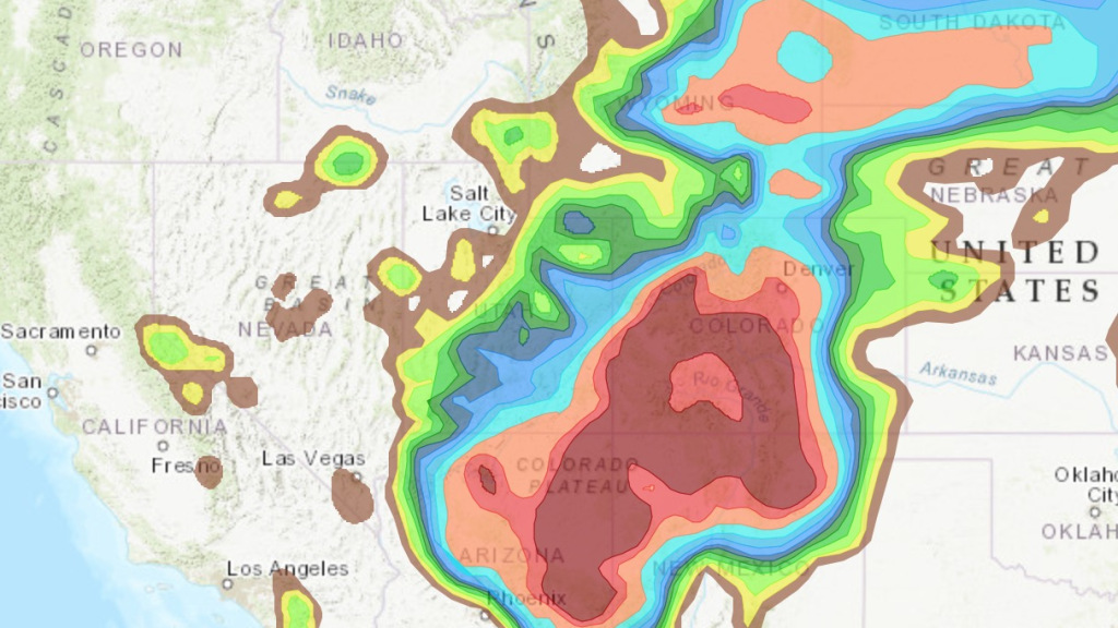
As of this morning, NOAA is projecting upwards of 2+ feet across the higher elevations of the San Juans and Sangre de Cristo mountain ranges. The highest totals are actually being forecasted in the Santa Fe mountains with Ski Santa Fe set to receive 31″ of new snow by Wednesday.
“In some areas. 5 to 16+ inches of snow will fall in the southwest Colorado mountains.” – NWS Grand Junction
Telluride, Silverton, Wolf Creek, and Taos will also be in on the powder party when the clock strikes midnight.
LET IT SNOW and HAPPY NEW YEAR!
Snow continues today in many locations. Southern locations (near the San Juans) will see snow continue through tomorrow. pic.twitter.com/lHM6FzTiFS
— NWS Grand Junction (@NWSGJT) December 31, 2018
Forecasted Snow Totals:
- Santa Fe, NM —
- Wolf Creek, CO —
- Taos, NM —
- Telluride, CO —
- Silverton, CO —
Snowfall forecast for today through Wednesday. Given the modified arctic airmass accompanying this system, even light snow accumulations will have major travel impacts. Stay safe. #nmwx #NYE2019 #NewYears2019 #NM pic.twitter.com/JpiJ5FRqkN
— NWS Albuquerque (@NWSAlbuquerque) December 31, 2018
Silverton Forecast:
Wolf Creek Forecast:
Taos Forecast:
Winter Storm Warning [San Juans]
…WINTER STORM WARNING REMAINS IN EFFECT FROM 6 AM THIS MORNING TO 5 PM MST TUESDAY…
* WHAT…Heavy snow expected. Total snow accumulations of 10 to 20 inches expected with local amounts up to 2 feet.
* WHERE…Southwest San Juan Mountains.
* WHEN…From 6 AM this morning to 5 PM MST Tuesday.
* ADDITIONAL DETAILS…Travel will become very difficult to impossible, especially along highway 550 from Red Mountain Pass south and Highway 145 over Lizard Head Pass. The hazardous conditions will impact the morning and evening commute, with road closures expected.
Winter Storm Warning [Wolf Creek]
…WINTER STORM WARNING REMAINS IN EFFECT UNTIL 5 PM MST TUESDAY…
* WHAT…Heavy snow expected. Total snow accumulations of 6 to 21 inches expected, with the heaviest snow affecting Wolf Creek Pass and the crest of the Eastern San Juan Mountains. Winds gusting as high as 40 mph.
* WHERE…Eastern San Juan Mountains and Upper Rio Grande Valley.
* WHEN…Until 5 PM MST Tuesday.
* ADDITIONAL DETAILS…Travel could be very difficult to impossible. Patchy blowing snow could significantly reduce visibility. The hazardous conditions could impact the morning or evening commute. The cold wind chills as low as 20 below zero could cause frostbite on exposed skin in as little as 30 minutes.
Winter Storm Warning [Taos]
…ANOTHER SIGNIFICANT WINTER STORM ON TARGET TO IMPACT NEW MEXICO TODAY THROUGH TUESDAY NIGHT…
A storm system gathering strength over the Pacific Northwest will move southeast toward the Four Corners region today. Meanwhile, an arctic airmass over southern Canada will surge south and arrive in northeast New Mexico late this afternoon. These two air masses will merge over New Mexico and develop into a significant winter storm for New Year`s Eve into New Year`s Day. Widespread snow, blowing snow, freezing fog, low visibility, and bitterly cold temperatures will likely result in major travel impacts over the region. The heaviest snowfall with this storm is expected to impact western and central New Mexico, as well as the high plains of eastern New Mexico.
…WINTER STORM WARNING IN EFFECT FROM NOON TODAY TO MIDNIGHT MST TUESDAY NIGHT…
* WHAT…Heavy snow expected. Total snow accumulations of 4 to 13
inches, except 7 to 20 inches above 7500 feet.
* WHERE….Northwest Plateau, Chuska Mountains, Far Northwest Highlands, Northwest Highlands, West Central Plateau, West Central Mountains, San Juan/Tusas Mountains, Jemez Mountains, West Slopes Sangre de Cristo Mountains, Northern Sangre de Cristos above 9500 feet, Southern Sangre de Cristos above 9500 feet, East Slopes Sangre de Cristo Mountains, Upper Rio Grande Valley, Raton Ridge/Johnson Mesa, Far Northeast Highlands, Northeast Highlands.
* WHEN…From noon today to midnight MST Tuesday night.
* ADDITIONAL DETAILS…Travel will likely be very difficult to impossible.
