Good morning everyone. I’m watching the sunrise over the Flatirons of Boulder looking at models struggling to find the deep this week.
Confidence is very high that the Pacific Northwest nabs 9-15 inches tonight into Sunday. A decent system will be stretched from north to south along the spine of the Cascades from Washington through Oregon beginning late today through Sunday evening. In Washington, 5-8 inches may fall tonight with another 4-7 by 11 AM Sunday. The northern Cascades near Mt Baker may actually see most snow from 3 PM Saturday to 8 AM Sunday. The Oregon Cascades will see most snow from early Sunday to late Sunday night. It’s possible that Mount Bachelor scores 11-18 inches of snow through Monday morning. The models are still not in synch for totals with the GFS bringing up to 2 feet and the Euro in the 9-15 inch range. I am inclined to go with the Euro. The Good: Mainly overnight and early AM snow for Washington. The Bad: There are some ice layers being reported from the rain even Thursday under the new snow. Some warming is noted on models for the southern Cascades of Washington and Oregon Sunday (Slightly upside down snow). Caveat: Moderate snow levels in the north (3000) with decent quality. Warmer in the south 3500 may cover the ice layers for your first chair Sunday. Trick: Some upper lifts may be closed in Oregon due to visibility or wind on Sunday (Heavy snow) so you may be able to chase from WA to OR on Monday.
Below: Total snowfall through Monday for the Pacific Northwest.
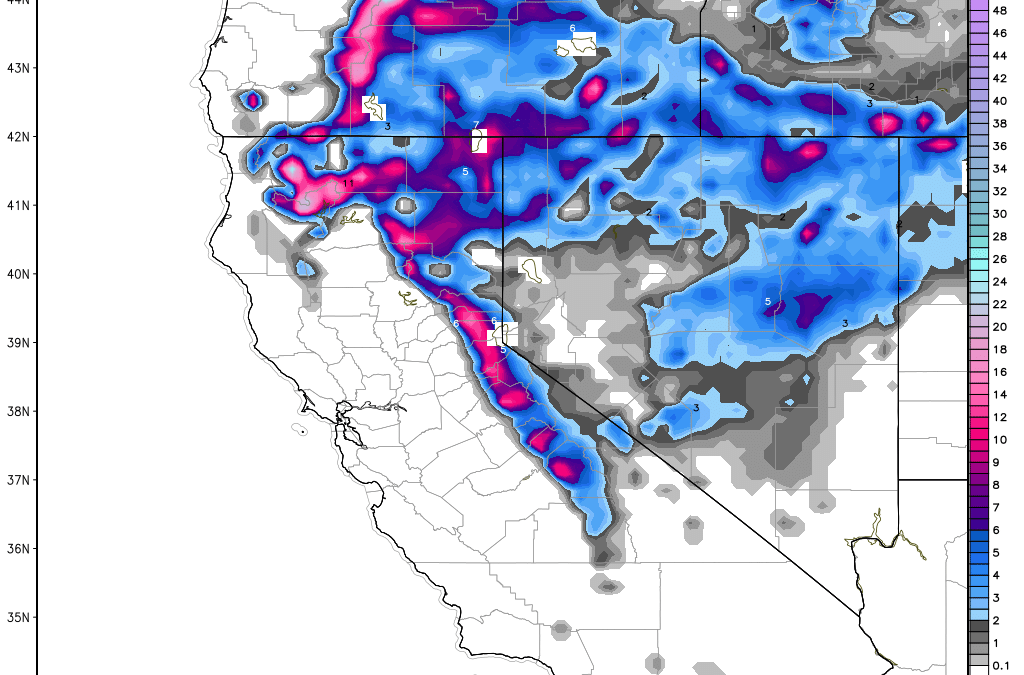
The Sierra is on tap for double digits at summit locations for XMAS day. This storm has a decent cold front, lowering snow levels but is fast moving. You may see a quick 6-12 inches (Base to summit) just as Santa is departing. The Good: Overnight snow. XMAS Day-. The Bad: Quick moving, so amounts may stay below a foot in some areas with summits in the deeper category.
Image: Total snowfall of a quick hitter for XMAS day powder in the Sierra
Elsewhere in the West, we are getting solid teases in the Wasatch with 6 inches overnight in the Cottonwoods, 4 inches at Beaver Mountain (Northern UT), and 3-4 inches in the Park City area. The Tetons grabbed 4 inches at Targhee. Steamboat is at 2-3 inches. Light snow is falling at Vail and Aspen with most of these teases ending by 10 AM. My forecast yesterday was calling for 3-7 inches in Utah and 2-5 inches near Steamboat. I over forecasted for Gunnison (CB) with about 2 inches on the stake (Still snowing) and 4-7 inches on the original forecast. The Vail Pass area had 3-7 on the forecast with 2-3 on the stake currently and snowing moderately.
The next 5 days is complicated with several systems teasing the Rockies. A more significant system will be felt in Colorado, Arizona, and New Mexico by Wednesday or Thursday. Snow showers will pick up Sunday in the Panhandle of Idaho, Central Idaho (Brundage). This will feature some light or moderate snowfall. Sunday night will feature the next good chance for 4-9 inches of powder for the Tetons (ride Monday) and the Wasatch. There is an isolated chance of higher amounts through late Monday or early Tuesday with snow showers continuing. It’s unlikely you will find any overnight double digits. I am slightly more confident for the Tetons than the Wasatch. I am less bullish for western Idaho. Models currently show some moderate amounts of snow for northern Colorado for Monday, especially near Steamboat. While we don’t have a large system impacting these areas, the sum totals of snow from Sunday to Tuesday could be respectable in many of these areas.
The extended is the complicated part. The departing Sierra storm is going to move east over the intermountain west by Tuesday night. Models are not in agreement on where the next low-pressure system ends up. My gut tells me that Tuesday night/Wednesday sees decent impacts for the 4 corners. I am putting Telluride, Purgatory, and Silverton on a solid watch list. Wolf Creek is on the next list. It is possible that double digits fall in these locations through Wednesday night. Arizona models show some snow for the Snowbowl near Flagstaff with heavier impacts on the eastern side of the State. Snow from the 4 corners will move east Wednesday night and most likely swoop northeast of many of the central Colorado mountains and significantly impact the eastern plains of Colorado. Some snow will stream north into the central mountains but it’s unclear how much. The optimist is that winds shift to the north that could really ramp up snow for the urban corridors near Denver and along I-70 at the Eisenhower tunnel. If the system edges closer to Denver we may score some freshies on the eastern side of Summit or Clear Creek Counties. It’s really hard to predict at this point. New Mexico is a solid contender for this storm. The winds are going to be SW initially that could do well at Santa Fe or even Taos.
Image: Boulder Colorado at press time.
Enjoy the powder everyone!
Powderchaser Steve
Source
https://powderchasers.com/forecasts/Updated-powder-forecast-Where-to-find-double-digits-in-the-next-5-days.-
