SUMMARY:
Models have not been in synch in the past 24 hours. The California storm may drag south of most of the Tahoe Basin Tuesday before slamming north Wednesday/Thursday. The Rockies are all in the game plan for this week primarily Thursday/Friday. The San Juan Mountains may sneak out moderate snow before the main event. Arizona is a solid contender Tuesday. If you’re in Vegas gambling hang up the chips and start heading north to the mountains! It’s Sunday night so take my post with caution before the next update sometime on Monday or Tuesday.
FORECAST:
Snow showers are continuing in the San Juan mountains of Colorado Sunday evening but quickly dissipating. Snow originally aimed at northern California for Tuesday is taking a southern route and will skim the mountains near Mammoth on Tuesday. Head to Big Bear if you want powder on Tuesday!
Below: Most moisture on Tuesday is focussed in southern CA just at the cusp of Mammoth or south.
Arizona is on solid watch for Tuesday where moderate snow will be falling for most of the day. Expect several inches to accumulate at the Flagstaff Ski area from before daybreak to evening Tuesday. Storm ski most of the day with some deeper freshies likely by the last chair.
Below: Moisture is feeding into Nevada and Arizona by late Monday night into Tuesday.
Southern Utah (Brian Head, Eagle Point) will be getting most of the action Tuesday or Wednesday. Some of that moisture trickles into the San Juans of Colorado during the daylight hours Wednesday (Moderate). I will update the amounts on the next post.
The extended forecast addresses the mid to late week storm that will slam several feet of snow into California and many States of the west.
EXTENDED:
Significant moisture will be aimed at the Sierra Wednesday/Thursday and perhaps Friday (Tapering).
Currently, the northern mountains of the Sierra are favored Wednesday (Moderate snow) with less towards Mammoth. Models have flip-flopped several times on this scenario. It’s likely you can storm ski Wednesday. Snow will be falling to lake level but may not be sticking to the roadways. Snow levels Wednesday are somewhat respectable for decent quality pow above 7,000 feet. Snow will increase significantly late Wednesday into Thursday morning for most of the Sierra Range. Unfortunately, winds will also increase late Wednesday into Thursday morning with gusts at the ridges in excess of 80 MPH. The models show a brief warm-up Wednesday night (Possible mixed precip at lake level) with mainly snow above 6,000 feet. That will add to rapidly rising avalanche danger!
Thursday brings steady moderate to heavy snowfall to the Sierra (continuing) with some decreases of wind speeds during the day. Colder air will be entering the Sierra by mid-morning Thursday. Snow quality will improve during the day with significant lake level snow (Snow level drops to 5,000 feet with the freezing level even lower). Thursday could skunk you completely depending on what lifts open (Pessimist). The optimist says, colder temps and high-quality freshies all day, decreasing winds by afternoon, may end up being one of the best storm ski days of the year. You may want to consider more wind protected terrain or slightly lower elevation resorts for Thursday depending on winds. Somewhere in the Basin will be opening lifts Thursday but it might not be your favorite lift or anything at the higher ridges.
Snow, will likely continue into Friday for the Sierra with colder air confined to the northern ranges.
Friday stands to be a better day in the Sierra for lifts or terrain to open. It could be really good!
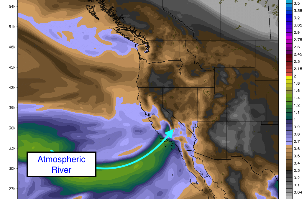
Below: Atmospheric River of moisture aimed at the Sierra
In the rest of the west, I am watching several chase opportunities. Most of the moisture from the Wednesday-Friday system have wind direction from the SW, S and even SE. Southerly flow will pump moisture over the Sawtooths of Idaho (Light on Wednesday- Heavy Thursday) so areas from Stanely to Hailey will benefit. Moderate to heavy amounts are likely in these areas. Moisture will also be pushing into the northern Panhandle and Cascades of Washington, Oregon. These areas all stand to see 5-10 inches late to this week with moderately cool temps. Cold air over northern Idaho and Montana will kick off decent quality by Thursday (Moderate or heavy snow showers at Schweitzer and light to moderate near Whitefish). The WA Cascades near Baker or Crystal may also benefit with colder temps. Many chase opportunities will exist. You may want to dodge the deepest snow or winds but it’s hard to resist the tail end of the Sierra storm (Colder and less wind).
Temps in the southern and central areas of the Rockies will be warmer. SW slow will be evident in the Tetons and Montana with snow falling from late Wednesday night (Light) to Friday. Moderate amounts are possible by midday Thursday. Snow will also be falling at Big Sky (moderate) with lesser amounts near Bridger. Thursday will be your best days to ride in these areas. The Tetons might hold on through Friday. Warm temps may limit amounts somewhat (1 inch per hour versus 2-3 but adding up nicely). I would expect 5-11 inches in the Tetons by late Thursday night with snow continuing on Friday. The Wasatch may win the game by Friday? It might be close.
Below: Temps in the Rockies Thursday are cold in northern Idaho and Montana but remain on the warmer side to the south.
In the Wasatch, it’s likely that moderate amounts will be evident by last chair Thursday with an increase of intensity late in the day. Moderate or heavy snow is likely in the Wasatch late Thursday/Friday as the winds shift to a more W-NW direction. It’s possible the Cottonwoods score deep powder for Friday morning? Areas also seeing higher totals may include the far northern mountains outside Logan towards Beaver Mountain. Ride Thursday afternoon and Friday.
Colorado is likely to see significant snow Thursday night into Saturday. The most significant amounts will fall on Friday. Currently, it appears the most favored spots in Colorado will be the western portions towards Aspen, Crested Butte, Sunlight, Powderhorn, Silverton, Telluride, Purgatory and Wolf Creek. Westerly flow turns NW late Thursday so areas along I-70 will see snowfall late Friday/Saturday (Lesser amounts than the areas west or south). I will get into more details as we get closer to the main event. The models are still in some disarray this evening so confidence in the extended period is a bit less than average. Expect powder for late Thursday (South or west) and Friday (Many locations) with leftover surprises Saturday (Northern Mountains). Steamboat shows some good totals and can benefit from SW flow initially and West flow with the wind shifts on Friday. Winter Park may see significantly lower amounts?
ANNOUNCEMENT: WELCOME our newest sponsor SNOSHARK who has reinvented the tool for removing snow from your car! This device will speed up your chase times, clearing snow in seconds versus minutes. Please check them out from the link above! Powderchasers uses these tools on our chases.
Powderchaser Steve
Source
https://powderchasers.com/forecasts/POWDER-ALERT-SIERRA-ARIZONA-POWDER-WATCH-CASCADES-PANHANDLE-TETONS-SAWTOOTH’S-WASATCH-COLORADO-