This ski season is just approaching the halfway point and already there have been as many days of snowfall as all of last season.
Aspen Skiing Co. has logged 42 days of snowfall since the lifts started turning Nov. 17 on Aspen Mountain. That ranges from a trace on a few days to a big dump of 15 inches of Jan. 22.
There have been 11 days with 6 or more inches of powder so far this season compared to 17 days of the 6-inch rule all of last season.
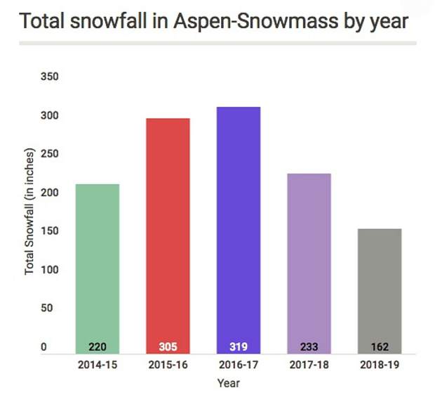
Aspen Mountain has collected 162 inches of snow since it opened early. That puts it on pace to match the best total of the decade in 2013-14, when 326 inches of snow fell.
This season hits the halfway point on Monday, assuming the slopes close as scheduled on April 21.
Chris Tomer, a meteorologist for the online service OnTheSnow, said La Niña dominated last season, which had a net effect of shifting the jet stream to favor the northern mountains of Colorado. That meant dry conditions for the Central Mountain, including Aspen.
“The snow just never came,” he said.
This winter is being influenced by a transition. Forecasters had expected an El Niño to develop, with a warming of sea surface temperatures. It hasn’t happened yet, but there has still been an important transition.
“I believe that shift from La Niña last season into a pseudo El Niño this season helped shift the storm track (jet stream) enough to deliver much heavier snow to the central mountains of Colorado including Aspen/Snowmass,” Tomer said via email. “It’s a complete change of fortune. It’s the momentum that counts.”
Tomer doesn’t expect a full-blown El Niño to develop this winter, but he still sees good things for the Aspen area. February and March look similar to what has been experienced so far, he said.
“I believe we’ll see at least normal snowfall in Aspen/Snowmass if not more,” Tomer said.
There will be a mix of southern track storm systems that favor the San Juan and other southern mountains in Colorado with northwest flow patterns that favor the central and northern mountains.
The local micro-forecaster Aspenweather.net also sees good things coming Aspen’s way over the second half of the winter. Meteorologist Cory Gates wrote on the website this week that he expects normal to above normal snowfall for Aspen in February and normal to below normal temperatures.
“Winter is going to last for the duration this year,” Gates wrote.
Snowmass has already topped 200 inches of snow this season, when considering snowfall starting Oct. 1, the website said.
The snowpack at the headwaters of the Roaring Fork River east of Aspen was 109 percent of median on Wednesday, according to a snow telemetry site operated by the Natural Resources Conservation Service. The snowpack is also above median at the headwaters to the Fryingpan and Crystal rivers.
Even so, most of Pitkin County remains classified as experiencing severe drought and the southern section is considered in extreme drought as of Jan. 24, according to the U.S. Drought Monitor.
OnTheSnow has tracked snowfall totals at Aspen Snowmass for the past decade. Its website includes a feature that allows comparisons between the seasons over that time.
Last season concluded with 233 inches of snowfall at Aspen Mountain during the time the lifts were running, the website showed. Contrary to popular perception, last season wasn’t the worst. Only 220 inches fell while the lifts were operating during the 2014-15 season and just 193 inches fell during 2011-12. There were just 41 days of snowfall that season, one fewer than so far this season.
The big seasons over the past decade, according to OnTheSnow’s data, were 2010-11 last season with 320 inches of snow, 2012-13 with 309 inches, 2013-14 with 326 inches and 2016-17 with 319 inches.
The average snowfall over the past nine seasons has been 272.5 inches.
