DENVER — We are tracking a storm that will bring snow to Colorado and possibly to Denver before Christmas night ends. There will be snow in the Colorado mountains Sunday night and again on Christmas Eve. Several inches of fresh snow are possible throughout the high country. The good news for holiday skiers is that there will be a chance of snow on Christmas Day in the mountains and each day after that through the end of next week.
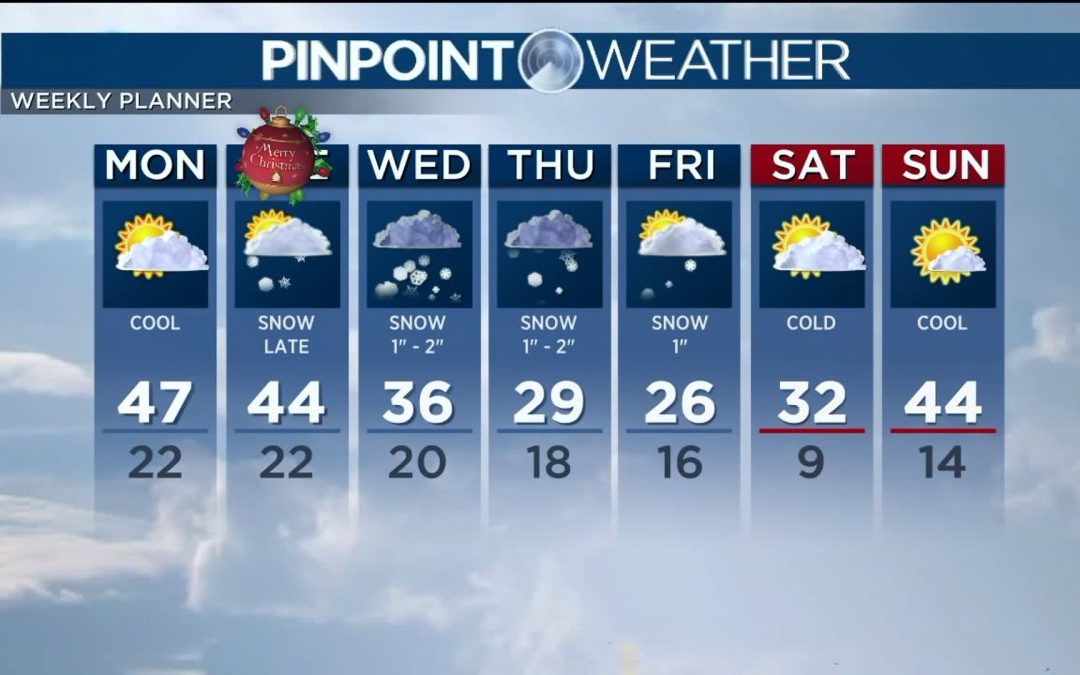
In Denver, your Christmas Eve will be quiet with passing clouds and cool temperatures in the mid to upper 40s. So, last minute shoppers should have no trouble running those errands.
Christmas Day in Denver will be partly sunny and seasonal with highs in the low 40s. A storm system will inch our way late Christmas night and could bring some light snow before the day ends.
That same storm system will deliver better snow on Wednesday through Friday along with lots of cold temperatures in the 20s and 30s. Right now, we are expecting between 2 and 5 inches of accumulation through the three days. So, it’ll break down to about an inch or two each day, especially Wednesday and Thursday.
Travelers: if you plan to head east of Denver on Wednesday or Thursday, be prepared for much heavier snow, gusty winds and poor road conditions. The storm that brings Denver light accumulation will drop more than a foot across the eastern Plains of Colorado. The Midwest will have the deepest totals along with some freezing rain, making travel there difficult for several days. Keep that in mind as you make plans to leave Colorado.
Check interactive radar and zoom in to where you are. Plus, check the radar anytime with the Pinpoint Weather App for iPhone and Android.
Pinpoint Weather has been independently certified as Colorado’s Most Accurate Forecast by WeatheRate.
We’re tracking weather today on FOX31 Denver and Channel 2 News – and when conditions are bad we send out the Weather Beast.