Today came in pretty close to my Teton Forecast of 6-12 with the mid-mountain Telemetry stake at Jackson at 14 inches by the close of the lifts Sunday. Upper mountain today felt more like 12-18 with blower conditions. Here is a shot from JHMR from my 1st run this morning.
Below:
Powderchaser Steve in the White Room at JHMR today.
Snow will continue lightly in the Tetons tonight with my forecast at an additional 1-3 inches by 6 AM. It’s possible higher amounts will fall at upper elevations. Significant snow will be falling in the Wind River Range of Wyoming tonight (Central Wyoming). Amounts of 12-15 inches are possible here. Snow is moving into the Wasatch tonight with a sharp cold front and convective high-intensity snowfall for several hours. At press time 4-6 inches has fallen in the Cottonwoods in just 2-3 hours. Park City on the Canyons side has 3-4 inches (Mid Mountain). Snow will continue this evening but my confidence for more than 5-9 inch totals is slim. If the lake kicks in tonight we could see higher amounts!
Colorado will see light to moderate snow showers in most of the northern and central mountains tonight through midday Monday. Models don’t impress (3-5). Better news happens Monday morning through Tuesday morning with 4-8 inches for Arizona Snowbowl. Snow will increase over the San Juan Mountains of Colorado Monday late AM through Tuesday. Winds are NW initially (Good for Telluride) with moderate snow likely. Winds play odd tricks by going SW, SE, and East. Models show 15-25 inch storm totals for areas near Durango and perhaps Wolf Creek. East winds are not common for the western San Juans. It might drop epic proportions of snow in the town of Durango. I would watch for an update on a future post. My gut tells me that Purgatory, Silverton, Telluride (Wildcard) and Wolf Creek will score deepness.
Below: Heavy snow for the San Juans mid-Monday through Tuesday (Ride late Monday or early Tuesday). Late Tuesday or early Wednesday may also offer pow. Regardless of odd wind directions, my highest confidence is Purgatory, Wolf Creek and perhaps less at Telluride. Silverton is a solid contender but east winds will not help. All areas of the San Juans will see decent snowfall with this storm but its tough to nail down exactly who gets the deepest. My next post will have more information. Southwest storms to me are the hardest to predict! The Tetons, Sierra, PNW, and Wasatch are relatively easy!
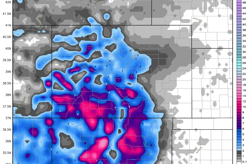
New Mexico is going to be in the headlines again next week. The image above shows very heavy snowfall for eastern sections and areas below Wolf Creek. I am more confident for Taos than the last storm with NE winds (better than SE we saw last week). I am not overly confident based on this map but believe 4-8 inches or more are likely for Tuesday (AM to PM).
If you’re still in the Tetons, enjoy the leftover powder plus new snow that falls tonight (Light). Some new terrain openings are possible at JHMR this week.
The extended looks warm and wet for the PNW mid week with a cooling trend towards next weekend. Coastal BC and the north Cascades may reap deep rewards late next week after the wet warm period. High elevations of BC will fare the best mideweek (Rain at the bases) Followed by colder temps Friday/Saturday (Snow below mid mountain). Moisture may wean by Saturday?
Powderchaser Steve
Source
https://powderchasers.com/forecasts/UPDATE-POWDER-TOTALS-FOR-NEXT-FEW-DAYS.-