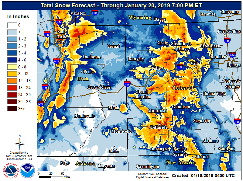
Another round of snow with a forecast of as much as a foot Friday is making travel difficult around Aspen and Snowmass and sparking avalanche warnings in the Colorado mountains.
The National Weather Service forecast calls for 6 to 12 inches of snow by Friday night and winds gusting to 35 mph in the central and northern Colorado mountains. The advisory area includes the Elk and Gore mountains, up to the Steamboat area and toward Vail.
Avalanche warnings have been issued for all of the central Colorado mountains from Wyoming to New Mexico as a storm rolls through the state, including around the Roaring Fork Valley.
According to the Colorado Avalanche Information Center’s Friday morning update, as of 6 a.m. “weather stations are showing 0.5 to 1.5 inches of snow-water equivalent, but only 6 to 8 inches of snow. Winds have been blowing in a good range to drift snow, with ridge top gusts over 40 miles per hour. Dense snow, falling at high rates, and lots of drifting.”
The National Weather Service advisory in in effect until 6 p.m., and an update Friday said the “hazardous conditions could impact the evening commute.” Mountain passes will be difficult for holiday travelers, as heavy, wet snow hits most of the Colorado high country.
The Aspen School District canceled classes for Friday because of the overnight snow.
Recommended Stories For You
Those traveling in and out of the Aspen-Pitkin County Airport should check their flight status before heading to Sardy Field.
Parts of southern and western Colorado are under a winter weather warning with more than a foot predicted in some areas, the NWS said.
The forecasted snow has increased the avalanche danger to high (level 4 out of 5) and backcountry travel in avalanche terrain is not advised, the Colorado Avalanche Information Center warned. This storm comes after up to 15 inches of snow fell Wednesday in the central mountains.
“Expect a heavy snow load on a weak snowpack beginning late Thursday night and continuing through Friday,” the CAIC said.
The avalanche danger will rise rapidly, according to the state agency, and slides will be large and easy to trigger or occur naturally in much of the Colorado high country.
The storm is forecast to clear out by Saturday, and the next chance for snow in the area on Monday and again Wednesday, the NWS said.